Geocam Map
Geocam essentially offers you two ways to look at the world around you. One trough the lens of your camera with a layer of extra information (see Main Screen) and one on a map. The map is linked closely with Geo Markers and Pictures. There are two ways to open the map:
- Geo menu, Map, Show Geocam Map
- From the Marker list, click on any Geo-Marker to view it on the Map
To export your picture and markers to Google Earth, see KMZ Export
The Map view
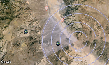
This view shows you three things:
- Your current position, where you are looking and a dynamic scale that helps you evaluate distance to objects on the map
- Pictures with the camera icon indicates photos your have taken and their location. Click on the icon to see details about the picture
- Geo Markers with the red marker icon. Again click on them to view details. Note that you can add a Geo-Marker directly from the map by clicking and holding at any place. You will then be asked to provide a name.